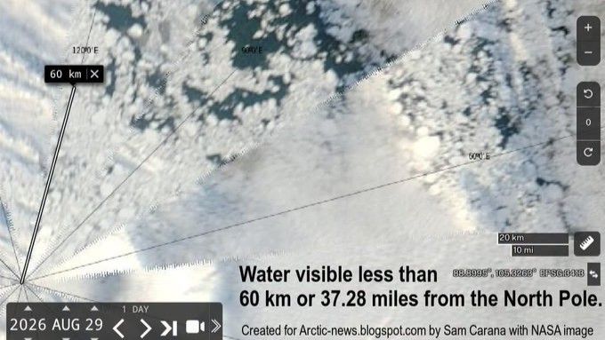
A NASA satellite image captured on August 29 reveals extensive stretches of open water located just 37 miles from the North Pole, prompting concern among climate scientists about the state of Arctic ice. While such occurrences have been documented before, experts emphasize that the visibility and extent of these water patches underscore the profound impact of climate change on the polar region.
According to polar observation specialists, the fragmented nature of Arctic sea ice during late summer creates conditions where open water appears more frequently between ice floes. Strong winds and ocean currents can dramatically shift ice fragments, causing gaps to expand or contract within hours. Although current ice extent levels are not necessarily record-breaking compared to recent years, the underlying composition has fundamentally changed, with ice becoming increasingly thin and brittle in recent decades.
Researchers caution that this satellite image represents a concerning indicator of the Arctic’s transformation rather than a unique crisis point. The region has experienced substantial warming—nearly four times faster than the global average—resulting in younger, more fragile ice formations where thicker, persistent ice once dominated. These changes carry significant implications for Arctic ecosystems, local weather patterns, and coastal communities facing increased erosion and flooding risks.
As autumn approaches, scientists anticipate that refreezing will begin by mid-to-late September, temporarily closing some of the visible water gaps. However, the broader trend reflects a fundamentally altered Arctic Ocean compared to decades past.
Originally reported by Livescience →
About the Author